Extracting useful & relevant information from Remote Sensing (satellite & airborne data) aids immensely during conceptualizing, planning, exploration, and mining phases of asset development.
Geospatial & GIS Services
Aid to conceptualizing, planning & exploration
GIS aids in analysing datasets of various genres & priority, in tandem, while planning the exploration program. Our Geospatial & GIS division aids in planning precision mapping services at different stages of development.
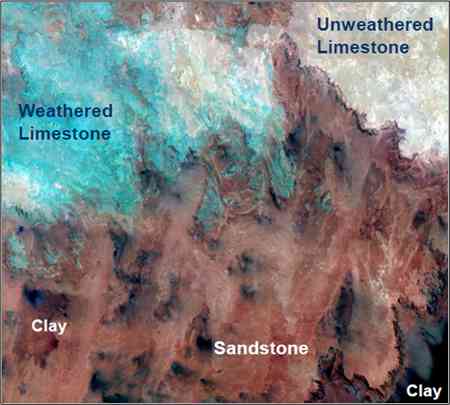
Mineral Abundance Mapping, a skillful exploit of multi-spectral satellite data to quickly identify precise target locations for detailed ground studies usually in large prospecting permits, is in the foray of Capstone’s Geo-spatial capabilities. Mineral information extraction & database creation using various genres of satellite data such as ASTER, LANDSAT, SPOT, SENTINEL, LISS IV etc. lies in the company’s professional experience. Most significant are locating hydrothermal alteration signatures for exploring gold & base metal targets zones, mapping of iron rich zones & gossans, identifying & delineating geological units, mapping ophiolite sequences, and interpreting geological structures etc. Capstone has conducted numerous such program in West Africa, East-Central & Southern Africa, wherein mineral assets could be prioritized for abundance of gold & base metals, by targeting large hydrothermal alteration areas. The procedures followed have produced enhanced results which could be assessed as high value information in subsequent on-ground investigations.
Remote Sensing not only enable identification of target location for on-ground assessments, it also is efficiently utilized to create database that has a bearing to overall development of the asset. Most significant are,
a) preparing regional topographic maps from satellite-based DEM (Digital Elevation Data),
b) extracting Physiography & Accessibility features,
c) Geological Formations & Rock Exposures,
d) Drainage network & its flow characteristics,
e) Vegetation cover,
f) Settlement,
g) Contamination potential,
h) Flooding potential and many other aspects that has a bearing to sustainable development of a mineral asset & downstream industries. GIS utilities enable enhanced analysis of multi-faceted information and churn the most comprehensive information enabling quick & efficient decision making.